
 November 14, 2018
The touching and insightful Disney Pixar film Coco pushed the Day of the Dead to the front of popular culture in the United States last year, but this celebration has been around for thousands of years in one form or another. The Day of the Dead is an established international holiday that can trace its roots back to indigenous traditions in the Americas and the Catholicism brought by the Spanish and other Europeans. Continue reading to hear about Chatham’s celebration of the holiday and see images of our ofrenda. Every year, between October 31st and November 2nd, families from different Spanish speaking countries prepare a celebration to honor their departed loved ones. This is a special occasion to remember their lives and celebrate their memories. Families gather to enjoy their loved ones’ favorite foods, listen to their favorite music, and share memories. This celebration is called el día de los muertos (Day of The Dead) and originated with indigenous cultures in parts of North (Mexico) and South America. With the arrival of Hispanic civilization, this celebration was embedded and merged with the Catholic All Saints Day and All Souls Day. Currently, el día de los muertos has become a tradition with both indigenous and Hispanic roots. This custom was brought to the United States by immigrants and recently has become very well-known and celebrated in many K-12 schools. To learn more about the Day of the Dead celebration, check out our Reference Guide on the topic: https://library.chatham.edu/dayofthedead
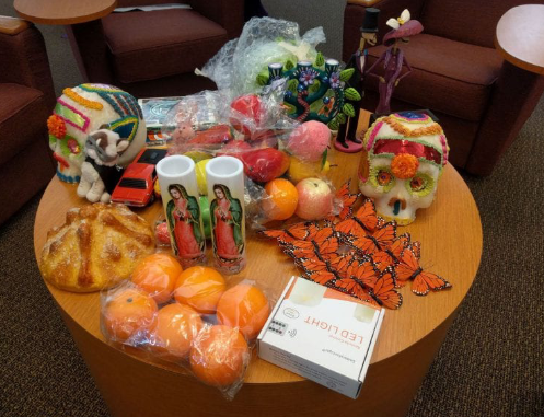
Chatham University celebrated el dia de los muertos for the first time this fall on Thursday, October 25th! This exciting event included an educational workshop about the holiday (its traditions and history) run entirely by Chatham students, a fun craft in the form of paper cempasuchil flower making, and a quick ceremony to honor our dead loved ones. As a university, we selected three people (or groups of people) to honor on the ofrenda. This year we voted to honor Antwon Rose Jr., Victims of Police Violence, and Victims of Mass Shootings, and each member of the Chatham community was encouraged to make a paper flower or a paper butterfly to add to the altar to remember a specific loved one. The altar was set up on the first floor of the JKM Library and remained up for a few weeks for others to view and pay their respects.
We also hosted a second event on el dia de los muertos (Friday, November 2nd) that consisted of a presentation on grief, a conversation about remembering departed
loved ones, and another hands-on craft. We made paper Monarch butterflies with our own personalized messages written on them while enjoying music and snacks. Folks
could keep their butterflies for themselves or add them to the wall around the ofrenda with others. We enjoyed Mexican hot chocolate and pan de muerto at both events!
These events were hosted as part of Chatham’s Latinx Heritage Month celebrations and sponsored by Modern Languages, the JKM Library, the Multicultural Affairs
Office, and the Counseling Center. A special thank you to adjunct professor Mildred Lopez Escudero for bring the program to Chatham and the JKM Library!
This November, the JKM Library launched a crowd sourced digital mapping project called “Whose Land Are You On?” in honor of Native American and Indigenous Heritage Month. We have a couple of goals for this project, which will be ongoing and updated throughout the years. First, we wanted to document where people in the Chatham Community grew up or considered their childhood home so we can see how far we’ve all come from. We then wanted to help the Chatham community educate each other on which indigenous people call/called that land home before being pushed out. We also aim to generate awareness around indigenous culture and the devastating effects of colonialism. Ultimately, we hope to honor those indigenous people and help stop the erasure of their presence from their own land.
So, how does this digital mapping project accomplish all that, and how can you participate?
We are using two digital tools to build our own map: Native Land and Google’s My Maps. Native Land is a project originating out of Canada and run by Victor Temprano as an engaging tool for awareness and advocacy. It is a dynamic project and comes with the caveat that it may contain inaccuracies. Victor acknowledges the maps many flaws in theory and in practice, but its intention is education, and that is how we are using it with this project. My Maps is a great tool from Google that allows us to create our own map with custom data. Anyone can access it and contribute to the map with their data.
To participate, you first look up your home town on the Native Land map. This website will tell you the different Native and indigenous people who lived on that land.
You then will want to go to our My Maps map, look up your home town again, and then drop and edit a pin in that location! We ask that you insert the Native tribal information into your pin so that others visiting the map will be able to see who called that land home before the colonizers. For in-depth instructions and images, please visit our guide at https://library.chatham.edu/whoseland and contribute a pin of your own!
Once you are done adding your pin, you can return to Native Land and take advantage of the informational links they offer on the Native tribes that pop up when you searched your home town. Click on those links and take 10 minutes out of your day to read up on them and their culture. Take that information with you as you head home
for Thanksgiving, and tell your family about the people whose land you are on. Thank them for being the stewards of that land, and talk about what you and your family can do to support them now.
We encourage everyone from any part of the Americas to participate! That includes Canada, Central, and South America. And don’t forget Hawaii! Native Americans are
not just indigenous folks from what we now call the United States. Borders have a habit of tripping us up, but if you are from a part of the world that has been documented by Native Land, please feel free to add it to our map. We will continue to ask the Chatham community to add to and browse this map in years to come. This project has no end date and will continue to be living and dynamic for as long as the tools we picked will allow. Check back in next year or the year after to see how it grows.
Commenting on blog posts requires an account.
Login is required to interact with this comment. Please and try again.
If you do not have an account, Register Now.